


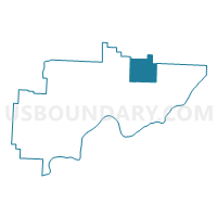
LIBERTY Voting District, Washington County, Ohio
About
Outline

Summary
| Unique Area Identifier | 653184 |
| Name | LIBERTY Voting District |
| County | Washington County |
| State | Ohio |
| Area (square miles) | 29.51 |
| Land Area (square miles) | 29.51 |
| Water Area (square miles) | 0.00 |
| % of Land Area | 100.00 |
| % of Water Area | 0.00 |
| Latitude of the Internal Point | 39.55680330 |
| Longtitude of the Internal Point | -81.30334930 |
Maps

Graphs
Select a template below for downloading or customizing gragh for LIBERTY Voting District, Washington County, Ohio


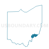
Neighbors
Neighoring Voting District (by Name) Neighboring Voting District on the Map
- ELK Voting District, Noble County, OH
- FEARING Voting District, Washington County, OH
- INDEPENDENCE Voting District, Washington County, OH
- LAWRENCE Voting District, Washington County, OH
- LUDLOW Voting District, Washington County, OH
- PRECINCT BETHEL, Monroe County, OH
- SALEM Voting District, Washington County, OH
Top 10 Neighboring County Subdivision (by Population) Neighboring County Subdivision on the Map
- Salem township, Washington County, OH (1,137)
- Lawrence township, Washington County, OH (901)
- Fearing township, Washington County, OH (891)
- Liberty township, Washington County, OH (481)
- Independence township, Washington County, OH (348)
- Bethel township, Monroe County, OH (347)
- Elk township, Noble County, OH (333)
- Ludlow township, Washington County, OH (328)
Top 10 Neighboring Unified School District (by Population) Neighboring Unified School District on the Map
- Switzerland of Ohio Local School District, OH (17,913)
- Fort Frye Local School District, OH (6,337)
- Frontier Local School District, OH (5,241)
Top 10 Neighboring State Legislative District Lower Chamber (by Population) Neighboring State Legislative District Lower Chamber on the Map
Top 10 Neighboring State Legislative District Upper Chamber (by Population) Neighboring State Legislative District Upper Chamber on the Map
Top 10 Neighboring 111th Congressional District (by Population) Neighboring 111th Congressional District on the Map
Top 10 Neighboring Census Tract (by Population) Neighboring Census Tract on the Map
- Census Tract 212, Washington County, OH (5,777)
- Census Tract 213, Washington County, OH (5,111)
- Census Tract 214, Washington County, OH (4,057)
- Census Tract 9669, Monroe County, OH (3,319)
- Census Tract 9685, Noble County, OH (3,210)